Since we took occupancy of our Mount Nathan property in August 2022 our daily rainfall records depict widely fluctuating conditions. There have been a number of high rainfall periods in this time with the most intense being in March 2025 with Cyclone Alfred with 710mm recorded over three days, and a total of 980mm for the month. There have been a number of months in the past three years where the monthly rainfall has been above the long term monthly average rainfall based on the official Bureau of Meteorology records from its Clearview Alert station 40846 located approximately 1km from our property. This information has been invaluable in planning and implementing land restoration, soil erosion and runoff control and channel stability works on our property.
Catchment Characteristics
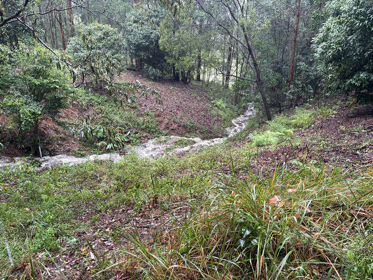
Our property occupies parts of two upper catchments of the Nerang River system which drain a large proportion of the eastern side of Mount Nathan. The southern drainage area is very steep with a fast flowing channel that is deeply incised into bedrock. Its catchment area is entirely forested right to our eastern boundary. The catchment area on the northern end of our forest is smaller in area and less steep than the southern catchment, and is the subject of this article.
The area of the southern catchment is 3.6ha of which 0.56ha is within our property. The length of the main channel is 375m of which 185m flows through our property. The elevation range is 160m from the summit of Mount Nathan to where the main channel leaves our property on the eastern boundary. The average slope of the total channel is 4.2% so it is very steep and fast flowing. Approximately 80% of the catchment is open eucalypt forest. Various rainforest species occur in the shady confines of the drainage line. The remaining 20% is advanced regrowth forest and portions of the lower catchment area were partially cleared in the past for grazing on our property and for banana plantation on the neighbouring property.
By August 2022 the drainage line within our property was in a very active phase of bed and bank erosion. There was little ground cover on the side slopes, beneath the thick cover of Lantana, Devils Fig, Tobacco Bush, Crofton Weed, Molasses Grass and Triumfetta. The ground surface was characterised by extensive sheet and rill erosion.
Restoration Plan
The restoration plan focused on the drainage channel and adjacent slopes and was divided into two zones. The objective was to restore channel stability by controlling erosion of the channel bed, control erosion on adjacent hillslopes, remove invasive weed species and induce regeneration of native species. These activities would take place in accordance with our Land for Wildlife Assessment Report prepared under the City of Gold Coast Community Conservation Partnership Program.
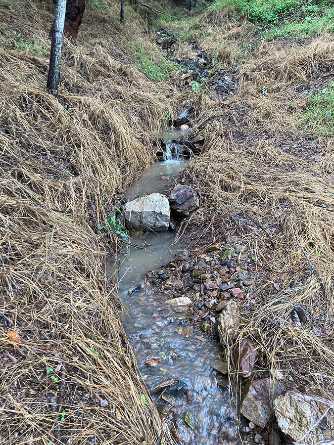
Zone 1 comprises the land from the upstream western property boundary to the ‘gateway’, where the channel slope flattens considerably being an old depositional area. Zone 2 comprises the area from the gateway to the downstream eastern property boundary.
Zone 1: Upstream Drainage Channel
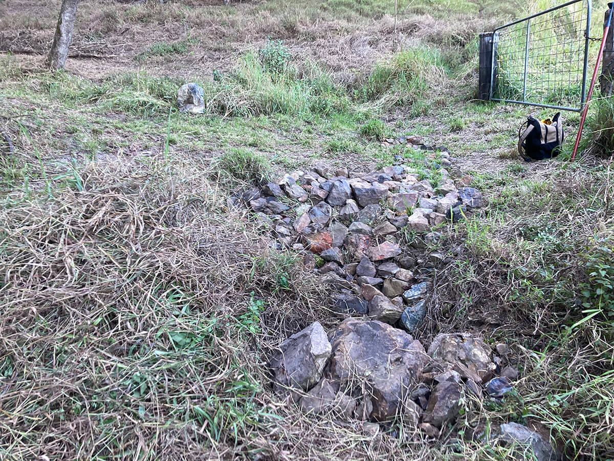
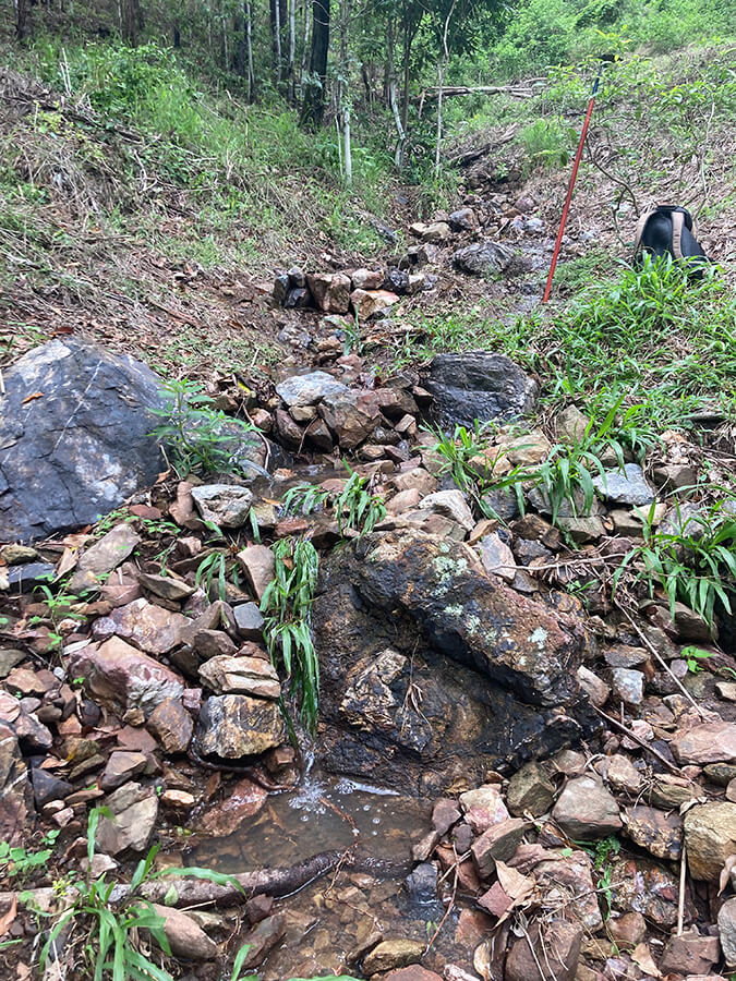
The length of drainage line in Zone 1 is 125m, with an average gradient of 2.7% at the property boundary, decreasing to 1.6% at the gateway. On occupancy, the area within the channel and its side slopes were heavily infested with Lantana, Tobacco Bush and Devils Fig. It was used by feral deer as a main thoroughfare. The initial focus was on weed removal, followed by construction of rock sediment traps, and rock lining to stabilise the channel floor and parts of the side walls to reduce bank undercutting. At those points where the channel was deeply incised, a rock flume was constructed to safely convey runoff through a 1-1.5 metre drop in channel level. The main hydraulic construction is the 10sqm rock flume at the gateway, to control the bed erosion in this area and to safely convey runoff to Zone 2.
Zone 2: Downstream Drainage Channel
The length of drainage line in Zone 2 is 60m and bed slope is 1.6%. The main focus in the deeply incised Zone 2 has been the construction of silt traps, rock lining the channel floor and some sidewall sections, and the construction of two rock flumes, and a plunge pool just beneath the Zone 1/ Zone 2 interface. Like Zone 1, the channel area in Zone 2 was heavily infested with Lantana, Tobacco Bush and Devils Fig which was removed prior to the constructed works.
Weed removal
By the end of 2022 weed removal in both zones had commenced mainly by hand pulling. The weed control method follows the natural regeneration methodology based on the South East Queensland Ecological Restoration Framework. The main species removed include Lantana, Corky Passionfruit, Brazilian Nightshade, Molasses Grass, Wild Tobacco, Chinese Burr, Broad-leaf Paspalum and Ground Asparagus. The cut lantana was spread as mulch, which has proved very effective for soil surface protection and moisture holding as a bed for emerging native species. Primary and maintenance sweeps have been carried out under our 2023-2024 and 2024-2025 City of Gold Coast Nature Conservation Assistance Program (NCAP) grants to reduce the re-emergence and spread of weeds downstream.
Ground surface treatment
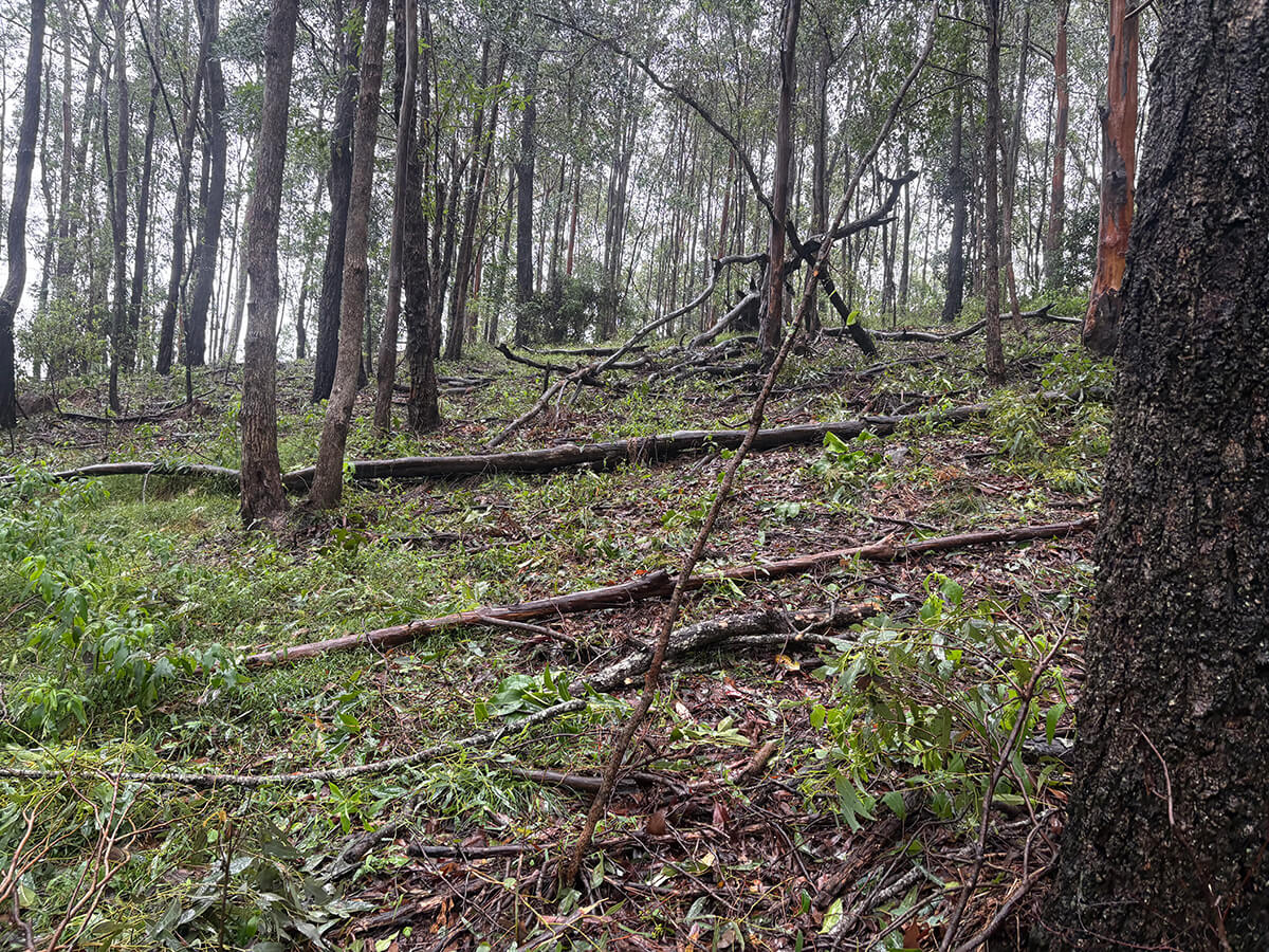
The two main structural forms implemented to control soil erosion of the land surface include rocks, branches and logs laid at right angles to the direction of the slope to reduce the speed of surface run-off and to trap sediment and debris. This is simple technology but is very effective when widely applied. These materials were used on the broad areas of hillslope and laid across small depressions where surface water concentrates. The basic principle is to slow the rate of runoff, trap and prevent sediment from reaching the drainage channel.
Feral Deer Management
The northern drainage line is an established feral deer corridor between the cleared lowland to Mount Nathan Reserve. The eroding, bare deer tracks are treated by constructing low rock and log barriers, and by placing branches across the slope to trap sediment and reduce overland flow.
Maintenance
Most of the works described above have been operative for two years now and have been tested by numerous high daily rain events as well as the extreme cyclonic event of March 2025. Regular inspections are carried out to ensure silt traps remain clean, and that rock and log barriers are in place. Sticks and branches are removed from the channel environment to prevent blockages. The natural steep gradient of the main channel, to a certain extent ensures ‘self-cleansing’ but because it is a high velocity channel there is always the risk of rocks dislodging, sending a destructive flood-wave down the channel. Regular attention ensures the in-channel protective works remain functional and stable.
Regular inspection of the slopes adjacent to the main channel is carried out to ensure that the rock and log barriers remain intact and to undertake any additional in-filling if necessary. Attention is on-going to the regularly used deer tracking corridor. On-going monitoring is essential to ensure that minimal sediment reaches the greater downstream waterway system of Nerang River catchment.

Article by Ian Hannam
Land for Wildlife member
Mount Nathan, Gold Coast
We gratefully acknowledge the valuable assistance and expertise of Melanie Mott, our Conservation Partnerships Officer from the City of Gold Coast.