Before I purchased my property in 1975 it had been used as part of a larger cattle property and was partially cleared. My 160 acres at Conondale is situated in the headwaters of the Mary River and covers a diversity of ecosystems from lowland riparian rainforest to wet sclerophyll and dry eucalypt forests on the drier spurs and ridges, which back onto Reesville on the Blackall Range.
The original survey map shows large areas depicted as ‘open grazing with apple gum’. When I bought the property there were also many large Banksias. This open structure, together with fire-adapted plants seems to indicate that the area was managed with regular burning by the traditional custodians.
“Burning off” was a common land management tool in my early days on the land. All the farmers around me burnt annually which meant I had to deal with several fires a year. Usually I wasn’t informed that my neighbours would be burning and it was often a matter of using back-burning to protect my property once I noticed a fire approaching. I often faced some dangerous situations with fires encircling my house. Because of this culture of uncontrolled, overuse of burning as a land management tool I became absolutely opposed to fire in natural habitats. I witnessed the dwindling away of my precious rainforest areas and many habitat trees were burnt down as fire entered their hollows. I believed that leaving the forest to its own devices would result in a healthier habitat.
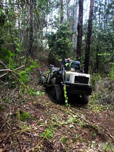
‘The Terminator’ – a posi-track with a front-mounted slasher was used to clear narrow, low impact, temporary containment lines.
In 2000 a huge wildfire, that was probably started by landowners burning off, rampaged through our valley and we couldn’t leave the house for a week or more. The result was astounding; everything was bare. It was as though the landscape had been given a Brazilian wax. You could see much further into the distance and see the underlying land formations. I considered whether this openness would have greatly assisted Aboriginal people to hunt.
I could also see the ground where lantana had previously covered it with dense thickets. Only the skeleton of the plants remained. This didn’t last for long though as they were quick to reshoot. It did however inspire me to start pulling them out as it was a much more achievable job. That was the start of my war against weeds.
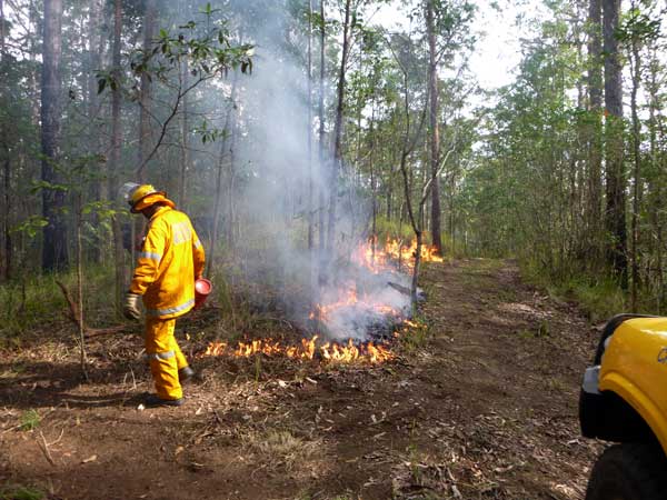
Fires are lit from the top of the hill and allowed to burn slowly downthe slope, note the low flame height and low wind conditions.
After the big wildfire, which evoked my love of weeding, I joined Land for Wildlife and developed a property management plan and undertook more strategic weed control. Since that time a lot of my property is now weed free and reverting into beautiful natural bushland. A few years back I noticed the emergence of a new understory of wet sclerophyll (along with lantana), under the eucalypt canopy that had previously had grass species. Bell Miners also seemed to prefer these habitats and the open forest has experienced a large extent of eucalypt dieback, which is compounded by the miners.
I started becoming more observant of the changes to the understorey and also read more research about fire as a management tool. Slowly I started to accept the idea of using fire as a habitat management tool. I consulted with Land for Wildlife and attended a fire management workshop which involved making a fire management plan for my property. My aim is to maintain tall eucalypt forests with a grassy understorey by limiting intrusion of rainforest plant species. This will help maintain the rich biodiversity of a grassy understorey and will hopefully help manage the Bell Miner Associated Dieback (BMAD).
My plan involved identifying areas that would benefit from burning and protecting areas such as rainforest that would be damaged by fire. I then divided the property into manageable sections to burn using natural features and decided upon the frequency and intensity of burning according to the natural vegetation types on the regional ecosystem map. Alan Wynn from Land for Wildlife assisted me to select the first areas. These were selected because they already had a diversity of grasses that warranted preservation.
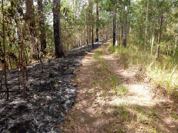
Old vehicle tracks make great containment lines and allow smaller areas to be safely burnt, resulting in a mosaic of patches at different stages of post fire regeneration, including unburnt areas.
That was the beginning of another long journey that involved finding old farm tracks and clearing them strategically and sensitively as access tracks for fire management vehicles, fire trails and fire breaks. I used natural control lines where possible such as creeks, gullies and existing infrastructure such as roads. To re-instate some firebreaks such as old tracks and fence lines I used a rubber tracked “terminator” which has a narrow front-mounted slasher. The roots and debris then needed to be pulled out, removed and areas raked. Other areas were prepared with a brush-cutter or my ride-on mower and raked.
The fire in 2000 was the last uncontrolled fire on my property and since then the local land management culture has also changed with the influx of new residents looking for a lifestyle rather than an income from their land. There has emerged a strong resistance to burning. Even the local fire brigades were reluctant to undertake planned burns and were overly cautious about suitable burning conditions. Neighbours were concerned and resistant. Two years in a row, planned burns were scheduled but the conditions were not suitable and the fires quickly went out by themselves.
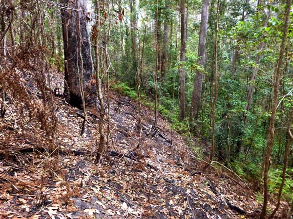
Example of a ‘natural containment line’ where the fire went out when it reached the vegetation closer to the gully. This area has a well-developed rainforest understorey and is less combustible in the conditions at the time of burning.
I have persisted and now have had three successful ecological burns on my place with the rural fire brigade being very supportive when they can provide the personnel (volunteers). These burns required a lot of planning and coordination with the rural fire brigade, fire warden (to obtain a permit), neighbours and other support people on the ground. Once the fire permit had been approved there were certain conditions that had to be met as well. Many hours of site preparation were required. Fire breaks and control lines were cleared and raked or even blown. The site was checked for trees that could fall across containment lines. Habitat trees, both standing and on the ground, were protected by raking away the leaf-litter from around them.
In initiating a burn the most critical decision is to determine the most suitable time considering the seasonal conditions, time of day, air humidity and dryness of vegetation. Conditions can change in a very short time and can either become too dry or too damp to burn. The rural fire brigade will come and assess conditions but often because of the short window of opportunity the resources (usually voluntary) cannot be assembled in time.
I have also had the advantage of advice from someone who has undertaken many environmental burns and can usually assess the conditions visually. I usually aim for a fire that burns consistently but doesn’t rise higher than about 1.2 m high. If the fire is too hot a lot of vegetation will be destroyed and if too cool the affect will be minimal and may need to be undertaken again. The best time is at the end of the day when the air is still dry enough but at the time when humidity is increasing so the fire will naturally slow down.
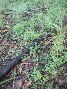
The soil seed bank is stimulated to germinate after a burn. Here masses of native legumes and fire-adapted shrubs such as Hovea acutifolia seedlings have germinated. Photo by Nick Clancy.
The addition of fire as a property management tool has been the element that has put the icing on the cake as far as managing my property. The first successful ecological burn was perfectly timed. The extent and intensity of the fire couldn’t have been better. I then immediately scheduled a second burn for the following weekend which again was perfect.
While some patchiness (unburnt patches) is a desirable outcome for ecological burns, my most recent burn last year was too patchy and had to be relit the following week. I have seen marvellous results especially in the flourishing understory of herbaceous plants and the increasing variety of grasses. I have even witnessed areas of trees seriously affected by dieback spring back to life. For the time being at least the Bell Miners appear to have moved on. I intend to burn my first two sites again after a period of four years then every five years.
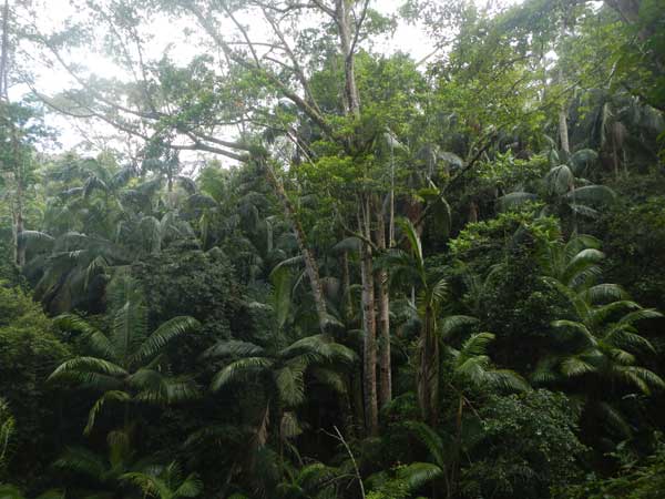
The strategy for rainforest areas, such as this one shown, on Di’s property is to exclude fire. To help achieve this, controlled burns are undertaken in adjacent open forests to reduce the risk of wildfires entering these fire-sensitive rainforests. Photo by Nick Clancy.
Article by Di Collier
Land for Wildlife member
Conondale, Sunshine Coast
Uncredited photos by Di Collier.