Aerial view over Rathburnie with the Brisbane River in the foreground and Lions Camp Duckadang on the far right.
A few years ago I had the opportunity to visit one of the largest privatelyowned Land for Wildlife properties in SEQ, the Rathburnie Estate Nature Refuge. It is administered by Valmai Burnett in accordance with her late husband’s bequest to the World Wildlife Fund Australia for the “demonstration, education and research into sustainable environmental/economic farming practices.” Valmai has lived at Rathburnie, overlooking the Brisbane River, for the past 65 years.
She is sharp, witty and passionate about sustainable land management that mixes conservation with primary production.
Although a million people would see the Brisbane River weekly, I think only a small portion would ever visit its headwaters in the “Valley of the Lakes” above Wivenhoe Dam. It is here where Valmai lives at the junction of Cooyar and Avoca Creeks where the “bright waters meet” at Avocavale, as in the Vale of Avoca in Ireland.
In the January 2011 floods, Valmai saw the Brisbane River rise to normal flood levels, when at midnight on the 10th of January, a “steering wind” and an abnormal column of rising cold air started dumping huge quantities of rain, which lasted about an hour. A wall of water came roaring down the gullies and the sound of the river in the dark was “absolutely frightening”. The river rose five metres above 1974 flood levels.
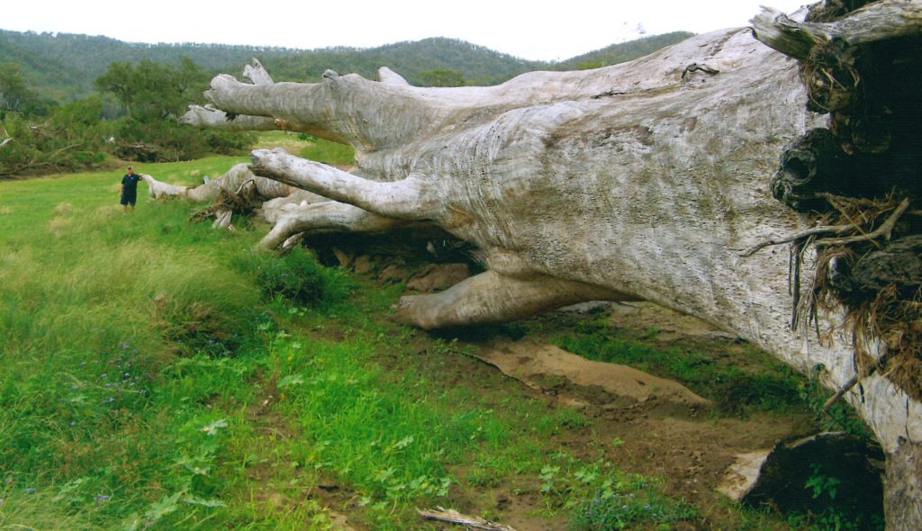
It wasn’t until the river fell again that the devastation was evident. Massive Blue Gums, hundreds of years old, which used to house Koalas were stripped from the river. Phone lines were washed away and radio provided the only weather reports.
The management of Rathburnie by Valmai and her late husband, Graham, has been influenced greatly by science, in particular the CSIRO Ecograze project. This project found that if alternative paddocks are spelled (i.e. cattle removed) in the wet season for three months to let native grasses grow and set seed, the carrying capacity of the land can be increased by up to 80%. As part of its commitment to sustainable land management, and in line with research findings, Rathburnie adopts a system of wet season spelling across six paddocks, each 300 acres in size, and each offering access to water.
Research has also shown that cattle only need 16% of their diet as protein, the rest can be roughage from tall native perennial grasses. Therefore, Rathburnie grows and harvests lucerne on the river flats to provide a protein supplement for cattle, and native grasses are allowed to grow tall to provide the roughage ruminants need.
“Rathburnie adopts a system of wet season spelling across six paddocks.”
When Graham purchased Rathburnie in 1932, he researched local Aboriginal campsites, such as the nearby Lions Camp Duckadang at the junction of Avoca Creek and the Brisbane River and ensured that buildings were also built on high ledges, above flood levels, just as Aboriginal campsites would have been.
Valmai has read widely about Australia’s land management history and shared stories from early European settlers who described this country as open woodland with widely-spaced large trees, and where tall grasses reached the horses’ bellies. European farming methods were originally productive due to the rich soil biota and humus (carbon) content, which had been built up under Aboriginal custodianship over millennia.
However, these fertile soils were quickly depleted and now landholders need to better manage shallow, ancient soils underlaid with salt and highly variable rainfall.
Valmai recounts how Rathburnie was once a real Garden of Eden where she would drink from the creek while listening to the tinkling of the Scarlet Honeyeaters. She hopes that one day Australians will enrich this land while being able to derive a sustainable income from it.
Article by Deborah Metters
Land for Wildlife Regional Coordinator
Healthy Land and Water
Photos by Valmai Burnett.
Just awesome to think that people like Valmai Burnett continue to maintain and manage the land in a sustainable manner to protect the environment for the benefit of all to enjoy people and animals especially. As a younh man after leaving Cherbourg i spent a fair amount of time on my own and with family and friends, also programs inthe valley area. I remember the forestry barracks and the fresh water food was plentyful. I only wish i had meet Mrs Burnett back in the early sixties tornading was one of the avtivities i was involved in at the time. Yeah fond memories and its my Traditional Country Jinibara and I’d love to meet Mrs Burnett.
Uncle Noel Blair. Would you like to come out and spend some time at this amazing place. sadly Mrs B has passed, but her long time friend and assistant to her wildlife Animal Refuge, still caretakes the sacred place.. if you see this message, phone marc on 0439 631 333 and also invite your nephew B J Murphy to sketch some scenery. Kind regards to you and your Jinibara peoples. 🙂